
Cloud4Geo
A shared cloud infrastructure for geoscientific data and services
Geoscientific disciplines such as meteorology, climate research and earth observation require high-performance digital infrastructures in order to be able to work with the rapidly growing volumes of measurement data and increasingly finer-resolution simulation models. This demand will continue to increase in the coming years due to new generations of geoscientific models / data assimilation systems. At an international level, programs such as Destination Earth (DestinE), the European Open Science Cloud (EOSC) and EGI take this need into consideration, as do commercial initiatives such as Gaia-X or the Google Earth Engine. At national level, infrastructures in the geosciences sector that pursue a cooperative approach and/or serve a public interest have been promoted and are now integrated into the European landscape of e-infrastructure providers. Future challenges require further expansion / networking of these e-infrastructures.
Aims of the project
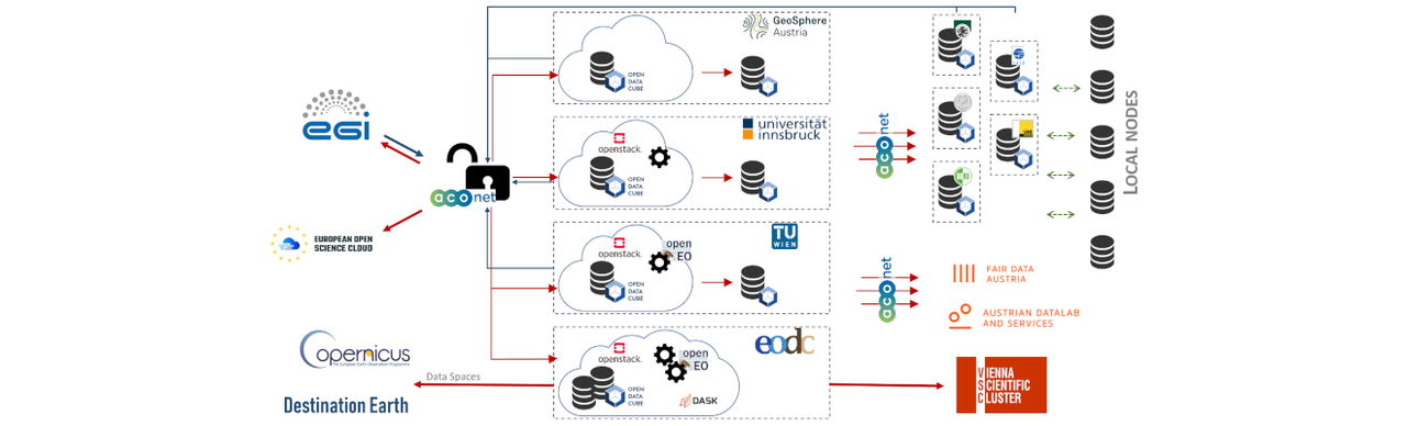
Building upon the existing infrastructure capacities of EODC, GeoSphere Austria and the Austrian universities, the project aims for developing a federal cloud infrastructure, integrated into the EOSC and EGI for the interdisciplinary use of FAIR data from various geoscientific disciplines in research and teaching. The expansion of shared services and the creation of jointly structured access to geoscientific data shall simplify their scientific use. This shall attract many new users from a wide range of geoscientific disciplines, which in turn will significantly improve the broad impact of the existing Austrian core facilities. It will also lay the foundation for the participation of Austrian organizations in the EOSC and EGI. Researchers will be put in a position to work more content-related, interdisciplinary and with large amounts of data.
Work packages of the initiative
- Identification of High-Value Geodata that are essential for the project partners’ research and teaching activities
- Creation of data management plans for the High-Value Geodata
- Development of a joint utilization concept for the High-Value Geodata in research and teaching
- Expansion of hardware components at / between the core facilities and project partners based on the utilization concept
- Step-by-step implementation of a single sign-on procedure
- Dissemination of new open-source software solutions for accessing, processing, analyzing and publishing geodata
- Integration into EOSC, EGI and other European infrastructures
Hero: c NASA, unsplash